
15 Sep Moving forward with technology: Headland is breaking new ground with photogrammetry
We are continuously working to improve efficiencies by investing in advancing technologies. As heritage professionals, our focus is to produce a cohesive record of the findings we uncover during excavation for future generations. Traditionally these would have been recorded using hand drawings, written descriptions and photographs. These forms of recording can be time consuming and at times not as accurate as we would like.
Recent years have seen heritage professionals embrace GPS and total stations for additional accuracy, thereby allowing an easier integration of archaeological remains with the national grid. We have a proactive Research & Development department at Headland whose sole aim is to improve efficiency through the use of technology. It is vitally important for us to enhance our service to ensure we can meet our clients’ financial limitations and save them both time and money.
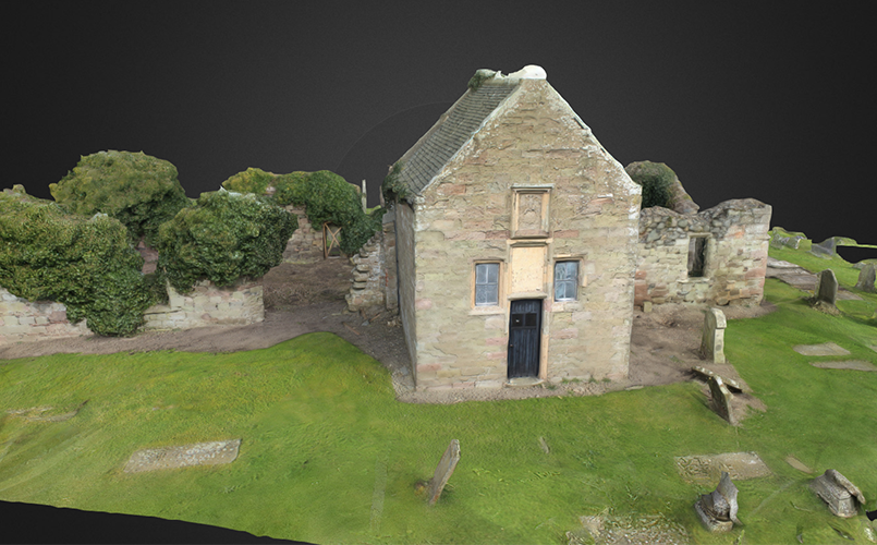
We have had a digital survey system in place for many years but due to recent technical developments we are beginning to use these in conjunction with photogrammetry to produce digital 3D models. This technique works really well across a range of features including underground archaeology and upstanding features such as walls and even whole buildings.
WHAT IS PHOTOGRAMMETRY?
Our brains perceive depth by comparing the images that our eyes see. If you alternatively close each of your eyes, you will notice that the object you see will seem to shift left and right. An object that is closer, will seem to shift more than an object that is further away. That is stereoscopic vision and the core concept behind creating the illusion of three-dimensional objects and space from two 2D images. Your brain can use this information to subconsciously calculate and tell you how far away an object is supposed to be. In a similar way, photogrammetry is a photography technique using software to map and reconstruct the shape of an object, by comparing two or more photographs. Photogrammetry is using a set of photographs to create a virtual three-dimensional model.
Photogrammetry requires us to take numerous digital photos from various positions and angles, including a bird’s eye view. The software then combines all the various images and effectively creates a 3D point cloud which can be rotated and interrogated. This provides a measurable record of many excavated features with sections, elevations and plans all being produced to millimetre accuracy not previously possible. Archaeologists and clients can use the images to boost online presentations, bringing the excavation to life.
HEADLAND, PHOTOGRAMMETRY AND BIM
Our technical team is working tirelessly on finding new ways to adapt our photogrammetry methods and we have undertaken a rolling training programme to ensure that our entire team, across our office network, are trained to use this technology.
Clients, particularly architects, have been impressed with photogrammetry as a recording technique, particularly as an alternative to standard survey and expensive laser scans.
Our adoption of photogrammetry for everyday on-site recording also allows us to effectively contribute to any Building Information Modelling (BIM). We can produce low-cost scanning data from our monitoring work, which can be fed into the BIM project to inform decisions on construction plans down the line. For example, we could provide a 3D model of archaeological deposits which could impact the placement of services, foundations and temporary enabling works on site.